Fluggebietskarte Alpen für Gleitschirm und Drachen
Fluggebietskarte Alpen für Gleitschirm und Drachen
Idealer Begleiter für Urlaubs- und Flugplanung
Von München bis Bassano – von Wien bis nach Monaco. Die Alpen bieten einzigartige Flugmöglichkeiten mit ausgezeichneter Thermik.
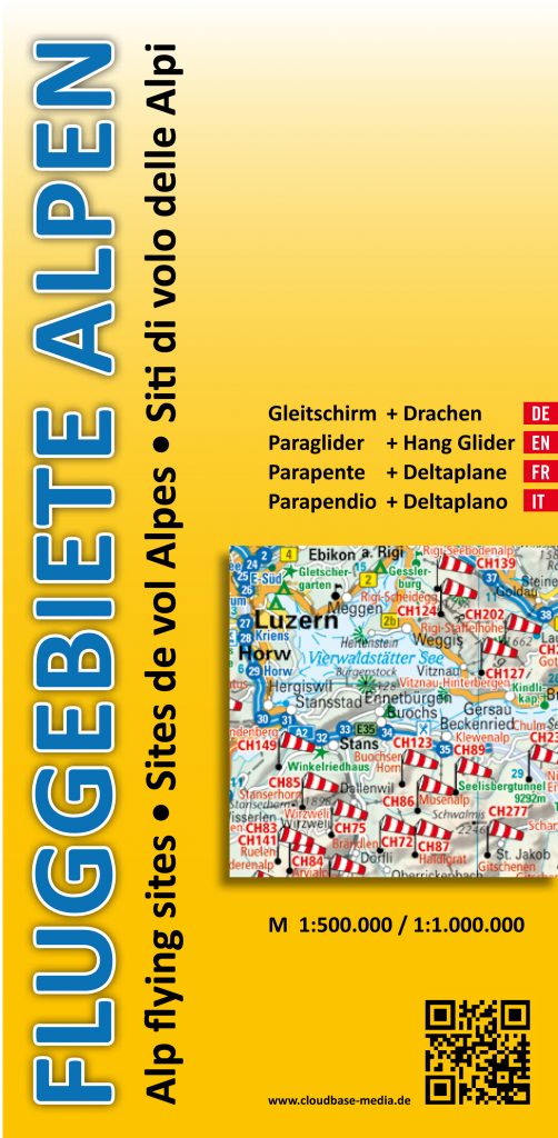
Die 4-sprachige (DE, EN, F, I) Fluggebietskarte Alpen für Gleitschirme und Drachen wurde speziell für Piloten aufgelegt. Sie enthält Informationen zu über 1.000 Gleitschirm- und Drachenfluggeländen in Deutschland, Österreich, Schweiz, Liechtenstein, Italien, Frankreich und Slowenien.
Auf einem Ost- und einem Westkartenteil sind im Maßstab 1:500.000 (Südalpen 1:1.000.000) alle Fluggelände übersichtlich dargestellt.
Ein eingeklebtes Booklet enthält auf 96 Seiten Daten zu über 2.500 Start- und Landeplätzen.
Die Karte ist zu einem Verkaufspreis von 17,80 € (brutto) zzgl. Versandkosten ab November 2013 bei den verschiedenen Verkaufsstellen (hier) erhältlich.
Alp Flying Site Map
Alpine Flying Sites Map
Ideal for planning flights and holidays
From Munich to Bassano, from Vienna to Montecarlo, the Alps offer fantastic flying for everyone.
This map is offered in 4 languages (English, German, French and Italian) and has been specially designed for hang- and paraglider pilots. It includes information on more than 1.000 different flying sites in Germany, Austria, Switzerland, Lichtenstein, Italy, France and Slovenia.
On separate East and West maps in 1:500.000 scale (southern Alps at 1:1.000.000) all sites are clearly displayed. An accompanying booklet attached to the map contains further detailed information on over 2.500 different launch and landing sites on a total of 96 pages.
The maps will be available from the end of November onwards and are priced at €17.80 each plus P&P.
Flying site map Alps for paraglider and hangglider
Alpine Flying Sites Map
Ideal for planning flights and holidays
From Munich to Bassano, from Vienna to Montecarlo, the Alps offer fantastic flying for everyone.
This map is offered in 4 languages (English, German, French and Italian) and has been specially designed for hang- and paraglider pilots. It includes information on more than 1.000 different flying sites in Germany, Austria, Switzerland, Lichtenstein, Italy, France and Slovenia.
On separate East and West maps in 1:500.000 scale (southern Alps at 1:1.000.000) all sites are clearly displayed. An accompanying booklet attached to the map contains further detailed information on over 2.500 different launch and landing sites on a total of 96 pages.
The maps are available and are priced at €17.80 each plus P&P.
Sites de vol Alpes – Parapente + deltaplane
Cartes sites de vol libre Alpes
De Munich à Bassano, de Vienne à Monaco, cette carte papier à l’échelle 1 : 500 000 (1:1.000.000 pour les Alpes du Sud) recense plus de 1000 sites alpins. Le livret attaché relate les coordonnées des différents décos et atterros de ces sites. Elle coûte 17,80 euros plus le port.
Mappa dei siti di volo delle Alpi – Parapendio + Deltaplano
Mappa dei siti di volo delle Alpi
Da Monaco a Bassano, da Vienna a Montecarlo, questa mappa in scala 1 : 500 000 (1:1 000 000 per le Alpi meridionali) contiene più di 1000 siti di volo alpini. Il libretto di accompagnamento fornisce le coordinate dei vari decolli ed atterraggi dei rispettivi siti di volo. Costa 17,80 euro, spese di spedizione escluse.